
Regional screening
Identify locations where methane-related signals warrant closer investigation.
HYPERSPECTRAL FEASIBILITY STUDY
Cropin explored whether hyperspectral Earth observation could distinguish greenhouse-gas signals over agricultural landscapes, and strengthen the evidence layer for future MRV systems.
Study evidence
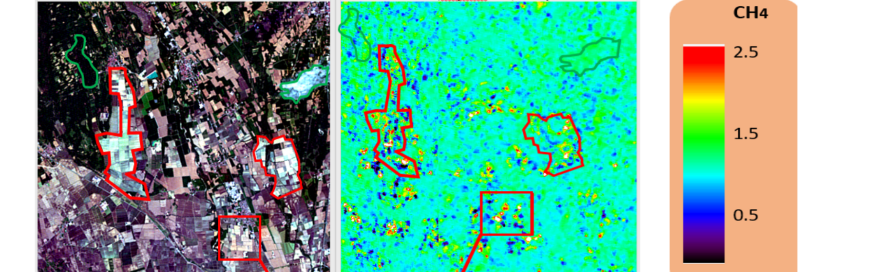
The report compared a PRISMA RGB observation of rice paddies in northern Italy with a processed CH₄ indicator. The resulting map showed a visible difference between rice fields and surrounding areas, despite expected atmospheric noise.
Cropin evaluated whether currently available hyperspectral observations could identify relative CO₂ and CH₄ signals. The research used PRISMA imagery and, for the broader CO₂ feasibility assessment, imagery from NASA’s EO-1 Hyperion mission.
02 / PUBLIC METHODOLOGYSelected portions of the short-wave infrared spectrum were processed to identify relative absorption-related patterns associated with CO₂ and CH₄. The public methodology is limited to the sensor class, observation principle and validation approach; Cropin’s implementation details, processing pipeline, feature engineering and operational thresholds are not disclosed.
03 / CO₂ RESULTThe CO₂ workflow was tested on a high-emission volcanic environment and compared with a rural reference area. PRISMA and Hyperion outputs produced comparable spatial patterns, supporting further investigation of hyperspectral CO₂ mapping. This was not a rice-field CO₂ measurement.
04 / CH₄ RESULTThe PRISMA-derived methane indicator showed a visible difference between rice fields and other areas. The output remained noisy because CH₄ is an atmospheric gas, but the contrast offered promising evidence that hyperspectral intelligence could support regional screening and monitoring.
Source: Cropin hyperspectral feasibility report. Research imagery includes PRISMA and NASA EO-1 Hyperion observations.
From research to enterprise value
The capability could help enterprises and governments screen rice-growing regions, prioritize field verification, monitor methane-reduction interventions and strengthen MRV workflows.
Identify locations where methane-related signals warrant closer investigation.
Compare spatial patterns across seasons and water-management programs.
Direct field sampling and verification resources toward higher-value areas.
EXPLORATORY FEASIBILITY WORK · RELATIVE SPATIAL INDICATOR, NOT DIRECT FIELD-LEVEL MEASUREMENT OF ABSOLUTE EMISSIONS · FURTHER CALIBRATION AND VALIDATION REQUIRED FOR OPERATIONAL USE